
A single drop of water…
It is raining today. The Sawtooths are barely visible through the thick layer of storm clouds. Sage is opening up, letting out its rough, raw scent. A scent which hints of home to any Idahoan. We are hoping that this rain will raise the water level in the river, if only a little bit. And make the season last longer, if only by a little while. We watch the rain fall and hope that those drops make their way to the Salmon. The rain inspires thoughts of the river’s formation: where that water came from, where it is going. Stanley can be slow at times. Staring out the window with only thoughts of moving water is not a rare occurrence on a rainy day. Do not judge. These types of wonderings and passages of time can be enlightening in their own right. For one, they made me examine more closely the Salmon River’s path. And now I can pass on what I’ve learned.
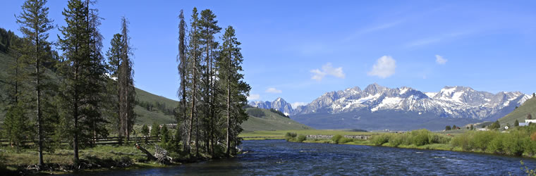
When driving from Sun Valley to Stanley, there is a sign on the side of the road indicating the tiny trickle that is the start of the Salmon river. Technically, this sign is inaccurate. The Salmon river starts far above the meandering stream. At the very tip of the Galena summit. Here is where the highest point in the watershed lies. And here is where the water which forms the Salmon River first starts to gather. Those tiny droplets of rain hit the summit and glide down, gathering momentum as they come together. Dipping in the lowest curves of the mountain, they all find the same path. First, the path is over piney soil or rock until finally the earth gives way, allowing those drops of water a gravely bed on which to glide.
Here is where the water passes under Idaho HWY 75 and “officially” becomes the Salmon River. More water from other angles of the watershed join. Streams which came from creeks which started from rain or snow flow into the river. Suddenly, the river is deeper, wider. Boaters and fisherman gather. The Salmon River is unique for many reasons. One, it is the longest free-flowing river in the lower 48. Two, it runs through the heart of the largest continuous wilderness in the lower 48 (Alaska trumps all). And THREE, it spends all of its miles flowing north. Apparently, water doesn’t flow uphill, but the Salmon has found a way to at least appear like it does.
Past Stanley and Sunbeam, the Salmon accepts water from the Yankee Fork and the East Fork of the Salmon. Past Challis and Salmon, the Pahsimeroi river joins its force and then the Lemhi river. The north fork, middle fork, and south fork of the Salmon come in. By this time, those droplets from Galena summit are joined by drops from summits all over central Idaho.
Finally, the Salmon river gives all that it has gathered to the Snake river. Water from Galena summit and the White Clouds join water from Yellowstone National Park and the Grand Tetons and other far off mountain peaks. The Snake veers from the odd path of the Salmon and flows west toward the Columbia. At the Columbia,ß water from even farther way is met until the river is carrying drops which rolled from peaks in Canada as well as America.
The deep, wide Columbia carries Galena summit water all the way to the Ocean. Here, like some sort of aquatic world fair, they meet drops from mountains from all over the world. Who knew water could be so multicultural.